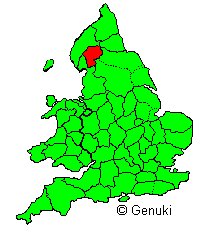
About the Westmorland CAMRA Branch
The Westmorland Branch of CAMRA covers the whole of the old county of Westmorland, along with the Sedbergh Rural District area that moved from Yorkshire to Cumbria in 1974. Basically it is the south eastern third of Cumbria, stretching from Langdale in the West, Eamont Bridge in the North, Brough in the East and Milnthorpe in the south. It is believed to be the only English CAMRA branch to have part of two national parks within its boundaries, namely the Lake District National Park and the Yorkshire Dales National Park.
The highest point of the branch is the summit of Helvellyn which at 950m (3,117 feet) is the third highest mountain in England. The branch also contains or shares the summits of many other notiable mountains including Crinkle Crags, Bowfell, Helm Crag, High Street, Fairfield and Whernside. Added to this are several of the Lake District lakes and tarns, the largest of which are Windermere, Ullswater and Haweswater. The branch covers a large area of 2,256 square kilometres (871 square miles) which is almost exactly a third of Cumbria.
In addition to the national parks, the branch also includes part of the Arnside and Silverdale and North Pennines Areas of Outstanding natural beauty, and the main industries are tourism and farming.
In terms of beer, at the last count there were 411 licensed premises within the branch area of which 189 were known to be serving real ale. These totals include a fair number of hotels. For more details on the pubs see the Cumbria Pub Database. A rough map of the branch area should be available here.
The following description of the former county is from the Barclay's Complete and Universal English Dictionary 1842. Not much has changed.

"Westmorland, county in N. of England; bounded NW. and N. by Cumberland, NE. by Durham, E. by Yorkshire, and S. and SW. by Lancashire and Morecambe Bay; greatest length, N. and S., 32 miles;. greatest breadth, E. and W., 40 miles; area, 500,906 acres, population 64,191.
Westmorland presents continuous succession of mountain, moor, and fell, intersected by deep winding vales, traversed by numerous streams. The principal of these are the Eden, Lowther, Lune, and Kent, the last forming the broad estuary which terminates in Morecambe Bay. The mountains consist of various ridges belonging to the Pennine and Cumbrian chains. Helvellyn, on the Cumberland border, rises to a height of 3115 ft. The western part of the county is within the Lake District, and contains Hawes Water, Grasmere, Rydal Water, and Ullswater on the Cumberland border and Windermere on the Lancashire border. The climate is moist.
The arable land is mostly confined to the valleys, where the soil usually consists of a dry gravelly loam, well adapted for turnips, but the greater part of the county is natural pasture. A few tracts of woodland remain of the forests which formerly clothed all the hills. The mineral productions include graphite, marble, roofing slate, and some coal, lead, and copper. The only manufactures of any consequence are the coarse woollens of Kendal. The county has good communications by railway."
An alternative spelling 'Westmoreland' was sometimes used in C18-19th.


